A couple of weeks ago I gave a short talk on lahar hazard issues to the Whatcom County Council. The talk was a bit of a follow up on a presentation that had been made to the County Council in February by geologists from the USGS Cascade Volcano Observatory and geologists who work for Whactom County. The USGS gave a presentation on Mount Baker Hazards and answered questions from the council.
Council Member Barbara Brenner had asked Don Easterbrook to speak at the Council meeting. Dr. Easterbrook had written to the council (
whatcom.wa.us/DocumentCenter/View/27435) that had some contrary opinions to lahar hazard mapping that has been done by the USGS. I was asked by Council if I would be willing to speak on the issue as well. This is in part because of information that I had forwarded to the Council that was contrary to Dr. Easterbrook's views as well as my technical review of the County geology hazardous areas regulations.
What follows are the slides I used in my presentation which was primarily on process and how public policy regarding geologic hazard and risk can be approached. Some elaboration as fitting is provided below each slide.

This slide was simply to go over the recommended geology hazard regulation changes. First I was a volunteer on Critical Areas Ordinance Technical Advisory Committee. (CAO TAC). I noted that most of the changes to geology hazard regulations were pretty minor and indeed none of the changes to the geology hazard code caused any consternation in later public reviews. I did suggest that the tsunami regulations be separated from seiche hazards as the two pose different levels of hazard. Whatcom County has no known seiche hazards but it can not be ruled out. The tsunami hazard is better understood and keeping the two separate made better sense to me. One area of erosion hazard was removed as it is my view that surface water run off erosion is better handled and is handled with other regulations. Lastly I noted that I did nothing with the code in regards to lahars and big landslide hazards due to the lack of policy guidance - it was and is my view that policy should come before code changes.

Just an image of what a lahar deposit looks like with a note that getting hit by this would be pretty destructive and rather difficult to mitigate.
Front bit for getting to policy guidance.
Language in the Whatcom County plan about Mount Baker. I underlined unpredictable as this was an aspect that I would discuss later.
Goal 10 E lays out the overall goal of the county geohazards approach. Underlined loss of life and expenditure of public funds because both individuals and society should be considered. Volcanic impact areas was underlined because that is why we were having this little talk. The last underlined part is also the area associated with regulations, but I did note that other means can be used to achieve the goal besides regulations alone.
This policy has been in the regulations and is a fairly common approach for infrequent but large geology hazards such as tsunamis and lahars fit in this as well. Generally you want hospitals or emergency response facilities located out of hazard areas.
This policy repeats an aspect of the goal can be achieved using multiple approaches, but again we are here to talk about the regulatory side, but in that regard other approaches that may be used should be considered.
This policy gets into why no action was taken regarding changing lahar hazard at the technical committee review point. Without public process and input making substantive changes would not be appropriate. If the process leads to a level of public risk that is acceptable, then the regulations can be written to meet that acceptable risk level.
This is really the same thing, but perhaps emphasizes approaching each hazard a bit differently.
Suggested approach in a very abbreviated manner. I noted that a new paper which will provide a very good overiew of Mount Baker geology and hazards is in review and will greatly aid in understanding the science.
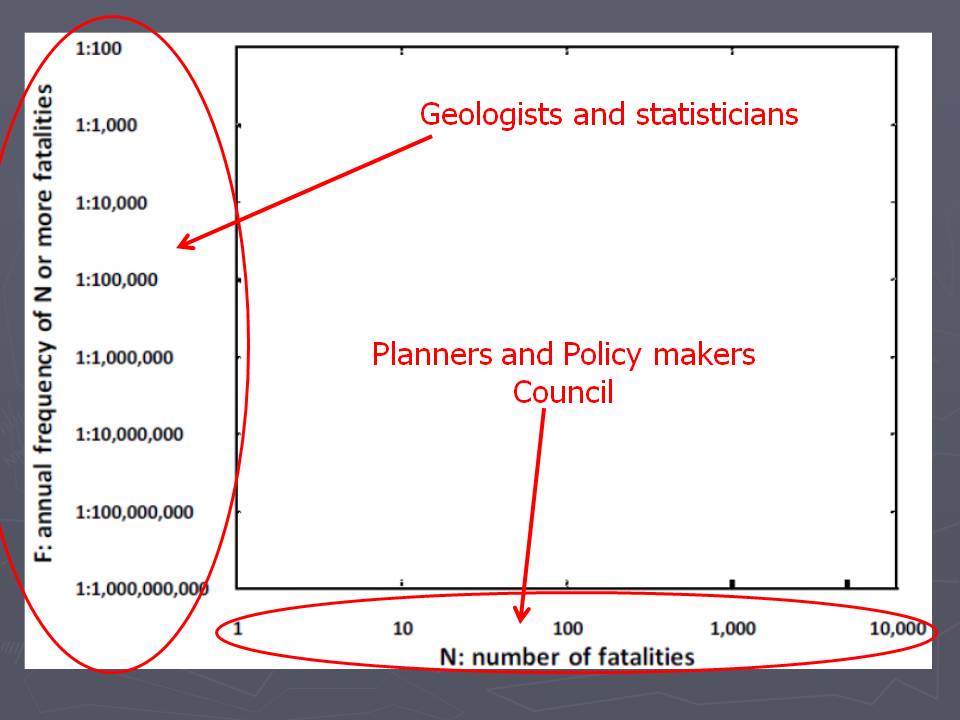
This is a blank chart that has been used for laying out acceptable risk levels for frequency and fatalities associated with geology hazards. It has been used in Hong Kong and in British Columbia.
The approach has some appeal in that it splits the tasks of plotting the risk between two groups. The geologists figure out what the annual frequency of an event taking place and then planners and policy makers assess the fatalities of the event. More on this chart later.
I lifted the sentence from an article on a completely different science subject, but feel it is applicable. Alas, I lost the reference so apologies to whoever really deserves it. The picture was lifted as well from a volcano hazard presentation from an Oregon County.
The emphasis was to link it to the fact that determining the potential for a hazard event taking place means that there will be scientific uncertainty, and scientists should be comfortable explaining the uncertainty to policy makers. I felt the the USGS folks had done a reasonable job at this during their presentation, but there things are worth repeating.
There is going to be uncertainty and pubic officials have to know that.
For Mount Baker, the history of lahars is a bit short due to the ice age. With one exception all the large lahars that may have come off the mountain have been erased due to the ice age glaciers covering the entire region. The USGS folks did a pretty job of covering this and I was repeating their points.
I put this map up to note that there had been lava flows including the youngest on the mountain that headed north (thanks David Tucker for the help with this). I felt putting this map up was important to counter a map that Don Easterbrook presented that had the exact same reference but left off the youngest lava flows on the north side of the mountain.
Just repeating myself.
People are not going to be banned from volcanic hazard areas. But it is useful to think about the types of populations and visitors that could be at risk depending on the policy approach and regulations.
With all the words and technical talk that can consume geology hazards, the point can get lost that geology hazards kill people. I will say that I got some push back post the talk about this slide. that push back came from people that are opposed to lahar hazard regulations and they were upset that the slide was playing on emotions. They are right, but I also think that it is too easy when trying to figure out potential hazards and run out distances from lahars or debris avalanches and getting excited about the science and policy impacts to property owners it is worth being starkly reminded about why we are even considering the regulations. The picture is from the
Armero tragedy of 1985 when over 23,000 people were killed by a lahar associated with a small volcanic eruption.
I got this idea of risk principles and have modified it a bit or a lot.
I noted that existing development was identified at risk elsewhere in Whatcom County and the risk was viewed as high enough that additional actions to protect people was taken. Purchases of very high risk sites and other actions.
Back to the blank graph.
I do not think the council nor was I ready to plot out any specific scenarios on the chart. But discussed some extreme end points. A 1:100 year event that could kill 10,000 people is not likely a very acceptable outcome.
What a distal muddy lahar looks like for people escaping.
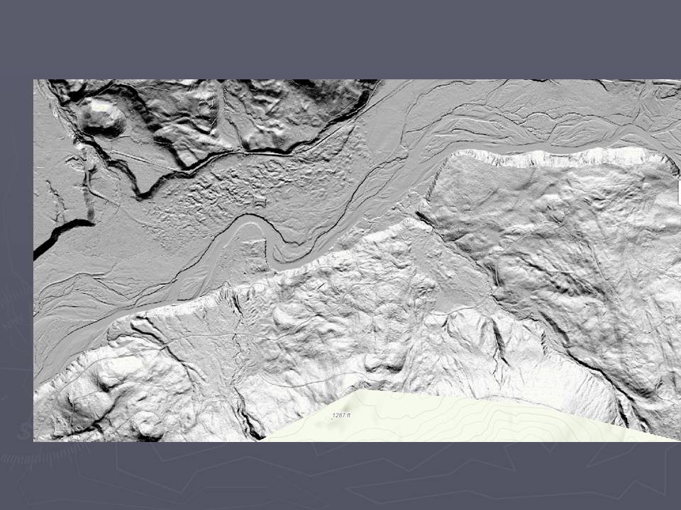
Besides lahars, large mountainside landslides are a similar problem in the mountain valleys. The LiDAR image above is the town of Glacier. Glacier would be impacted with very little warning time if a lahar or debris avalanche descended down Glacier Creek from Mount Baker. But another hazard is evident at Glacier - the valley floor is covered by a large landslide deposit - the lumpy ground evident in the LiDAR imagery.
Just up the North Fork Nooksack River from Mapple Falls is another area of lumpy ground from a large landslide that covered the valley floor.
This large landslide is east of Kendall. The scarps at the top of the slide appear recent in the LiDAR and I observed fairly fresh fractures on the headwall area of this slide when I last visited the slide.
This slide has been called Devil's Slide and covers the north end of the South Fork Nooksack valley near the confluence with the main stem of the Nooksack River.
Geologists like this, but I also think it is the geologist's job to give notice to civilization and thus change the phrase. To some extent Durant may have been inspired by the destruction of historic sites such as what took place at Vesuvius.
Some credit where it is due. The Scott and others paper is most helpful on the lahar hazard issue. And David Tucker provided some good guidance as well.


1 comment:
For a common sense approach to lahar hazard planning check out the following link:
http://www.whatcomcounty.us/DocumentCenter/View/26871
Post a Comment